In genealogy, knowing the locations associated with an ancestor is as important as knowing the facts of their life. Locations provide important context. With Iranian genealogy, geographical location can give clues to an ancestor’s ethnicity, language, and religion. In short, especially in Iranian genealogy, to best understand an ancestor’s life, you must understand the area in which they lived.
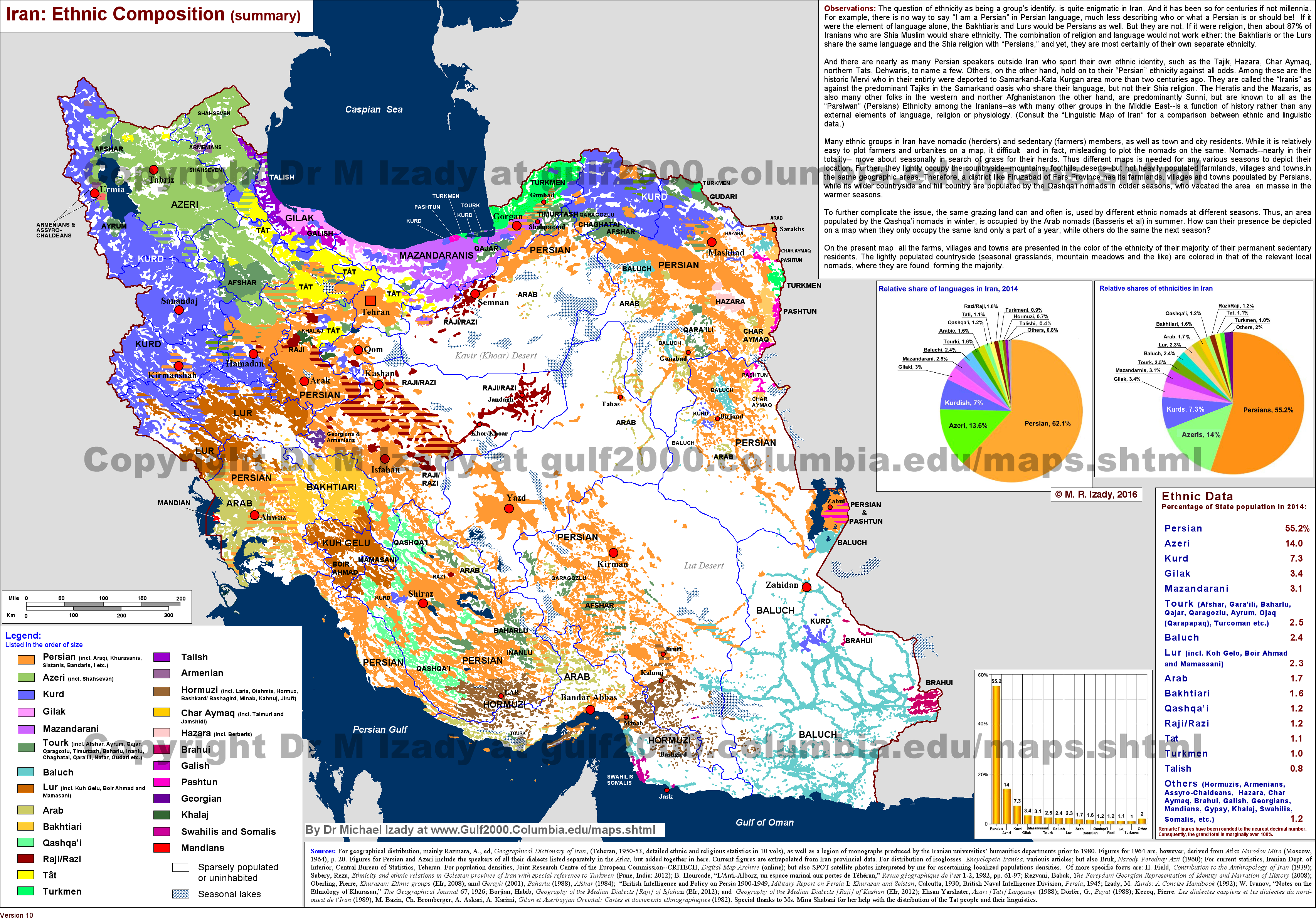
Ethnicities & Languages
The Atlas of the Languages of Iran is an excellent resource that both explains and visualizes which languages are spoken in Iran at the village/city level.


Place Names (Toponyms)
When researching the locations in genealogy, bear in mind that the names of many Iranian streets, villages and cities, provinces, and other political subdivisions have changed over time.
During the Qajar Era, many Iranian cities and provinces had titles that were often used in lieu of the location’s name in documents. Examples of these titles are listed below (Wikipedia (Farsi), Vāzhenāme-ye divāni dar dore-ye Qājār (Qajar Era Court Dictionary)). They were abolished in 1935 (Houchang E. Chehabi, Onomastic Reforms, 56). For a comprehensive list of city titles, see Jafar Sāmeni, Farhang-e alqāb va anāvin-e shahrhā (Dictionary of Cities’ Titles).
- Dār al-khelāfeh (دارالخلافه): Tehran
- Dār al-imān (دارالایمان): Qom
- Dār al-amān (دارالامان): Kerman
- Dār al-doleh (دارالدوله): Kermanshahan
- Dār al-saltaneh (دارالسلطنه): Tabriz, Esfahan, or Qazvin
- Dār al-ebādeh (دارالعباده): Yazd
- Dār al-elm (دارالعلم): Shiraz
- Dār al-marz (دارالمرز): Astarabad, Mazandaran, or Gilan
- Dār al-momenin (دارالمومنین): Kashan
Reza Shah Pahlavi changed over 107 toponyms during his reign (1925-1941), mainly in Turk and Kurd localities (Shohre Jalalpoor, Changing the Names of Cities in Iran in the First Pahlavi Era and the Role of the Language Academy of Iran, Ganjine-ye Asnad, Volume 22, Issue 88, 42-63, 2013). Examples include Bandar Anzali becoming Bandar Pahlavi, Tonekabon becoming Shahsavar, and Orumiyeh becoming Rezaiyeh. After the Islamic Revolution in 1979, the government reversed most of the Pahlavi Era toponymic changes, including street names.
For an analysis on the origin of Iranian place names, see Alice Assadorian, On the Systematic Classification of Iranian Toponyms.
Iranian documents often feature the names of locations that Iran had significant contact with or that used to be part of Iran.
- Atabāt (عتبات): the region in Iraq encompassing the cities of Karbala and Najaf, which are significant to Shia Muslims
- Farang (فرنگ): Europe
- Ghafghāz (قفقاز): Caucausus, which until the 1820s, belonged to Iran; it encompassed the following frequently mentioned cities/regions:
- Bāku (باکو)
- Gharabāgh (قره باغ)
- Nakhjavān (نخجوان)
- Shirvān (شیروان)
Political Subdivisions
The names of most of Iran’s various regions have remained similar since antiquity. However, Iran’s political subdivision system and the political subdivision names have changed more often. An ancestor, without moving, might have lived in several different political subdivisions throughout their lives. To fully grasp the significance of your family’s geographical location, it is helpful to have an understanding of the history of Iran’s political subdivisions.
| Qajar Era (1790s-1820s) | Qajar Era (1820s-1907/8) | Qajar/Pahlavi Era (1907/8-1938) | Pahlavi Era (1938-1983) | Pahlavi Era (parallel political subdivisions) | Islamic Republic (1983-present) | Islamic Republic (parallel political subdivisions) |
| hokmrāni (حکمرانی) (governate) | eyālat (ایالت) (state) | eyālat (ایالت) (state) | ostān (استان) (province) | farmāndāri-ye kol (فرمانداری کل) (governornate) | ostān (استان) (province) | |
| hākemneshin (حاکمنشین) (gubernatorial district) | velāyat (ولایت) (governate) | velāyat (ولایت) (governate) | shahrestān (شهرستان) (county) | farmāndāri (فرمانداری) (sub-governornate) | shahrestān (شهرستان) (county) | |
| eyālat (ایالت) (state) | boluk (بلوک) (block) | bakhsh (بخش) (district) | bakhsh (بخش) (district) | |||
| nāhiyeh (ناحیه) (district) | dehestān (دهشتان) (rural district) | city (شهر) | dehestān (دهشتان) (rural district) | |||
| ghasabe (قصبه) (village)/ deh (ده) (village) | village (روستا) |
At the beginning of the Qajar Era, Iran was divided into 5 hokmrāni (governate), which were further divided into eyālat (state). Groupings of a few eyālat made up a hākemneshin (gubernatorial district, literally “seat of a hākem (governor)”).
By the 13th Solar Hejri century (starting in 1820s), the political subdivision structure had been altered to consist of 4 eyālat (state), which encompassed 23 velāyat (governate, ruled by a vāli).
On December 19, 1907, Iran’s first Majles passed “The Law on the Formation of States and Governates and the Instructions of Governors” (قانون تشکیل ایالات و ولایات و دستور العمل حکام). The law divided Iran into 4 eyālat (state) and 12 velāyat (governate). Each velāyat was divided into boluk (block), which were further divided into nāhiyeh (district). Most velāyat were under an eyālat, but some were independent.
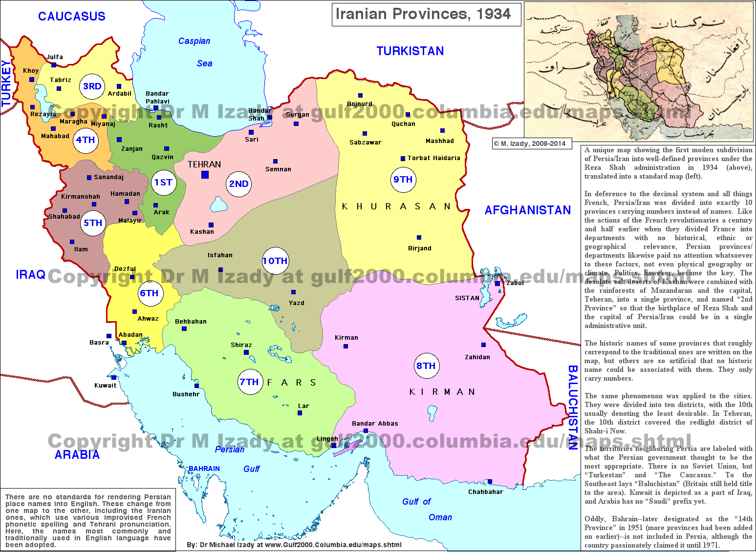
On November 7, 1937, the Law on National Divisions and the Responsibilities of Governors (قانون تقسیمات کشوری و وظایف فرمانداران و بخشداران) was passed. The law created a new political subdivision system, which organized Iran into ostān (province), shahrestān (county), bākhsh (district), dehestān (rural district), and ghasabe and deh (boroughs). Initially, under the law, Iran was divided into 6 ostān and 50 shahrestān. Within a month, the number of ostān was increased to 10, consisting of 49 shahrestān and 490 bakhsh. The ostān were assigned numbers instead of their traditional names. The map below shows the political subdivisions as they appeared at this time.
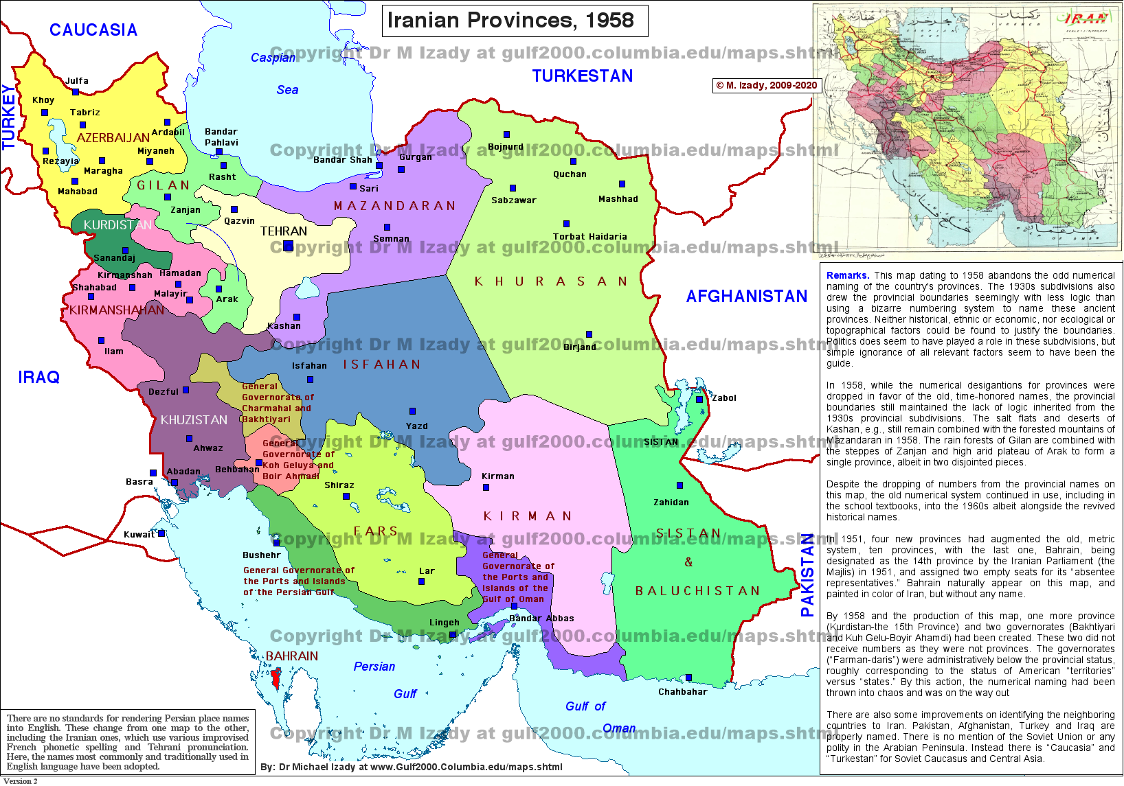
Throughout the reign of Mohammad Reza Pahlavi (r. 1941-1979), this political subdivision system was altered slightly. Ostān were again called by their traditional names, and, over time, the number and borders of ostān changed. The Pahlavi government also created new political subdivisions called farmāndāri-ye kol (general governate) and farmāndāri (sub-general governate), which were equivalents of, and existed alongside, ostān and shahrestān, respectively. See the two maps below for examples of the political subdivisions during the reign of Mohammad Reza Pahlavi.
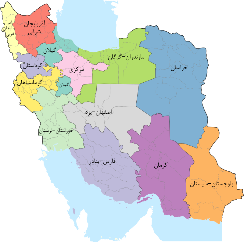
The Islamic Republic largely adopted the Pahlavi era system of political subdivisions. A law passed in June/July 1983 (Tir 1362) divided Iran into ostān (province), shahrestān (county), bakhsh (district), shahr (city), and dehestān (rural district, made up of rustā “village”). This system remains to this day. The maps below show the political subdivision changes throughout the existence of the Islamic Republic.